Thinking about owning your own stretch of the James near Big Island? You are not alone. Riverfront and near-river acreage here blends quiet mountain views with year-round recreation, but the details matter. In this guide, you will learn how the river behaves around Big Island, what permits and property rights to confirm, where to access the water, and what costs to expect so you can buy with confidence. Let’s dive in.
Why Big Island stands out
Big Island sits in northern Bedford County along the non-tidal James River. In this reach, the river alternates between pools, riffles, and ledges, and it supports strong smallmouth and catfish fishing. The Virginia Department of Wildlife Resources outlines float trips and ramps across the upper and middle James, which includes the Big Island area (DWR river overview).
Hydropower dams near Big Island, including the Cushaw project, shape local currents and depths. These low-head structures create deep pools and hazardous tailraces, and they can affect put-in and take-out choices. Before you buy, map nearby dams and note any posted restrictions or hazards (Cushaw project background).
What to check before you buy
Zoning and parcel research
Start with the county’s parcel viewer and zoning tools to confirm parcel boundaries, zoning, and flood layers. Bedford County Community Development can answer questions on land disturbance, floodplain rules, and building requirements (Planning and Zoning).
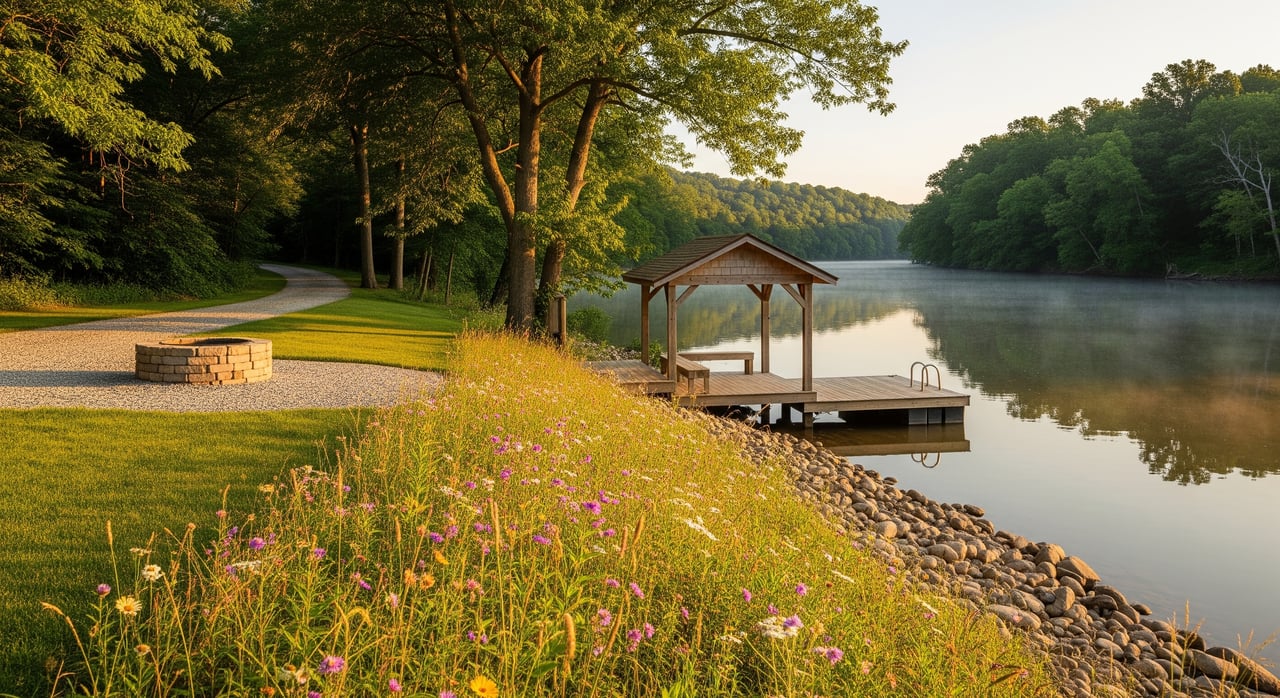
Riparian rights and shoreline use
In Virginia, waterfront owners may have riparian privileges, but rights depend on title and state law. Verify in the title work whether riparian rights were ever severed, and whether any easements or reservations affect your shoreline. Any dock, ramp, or bank work that impacts waters or wetlands may require permits through the U.S. Army Corps and state partners. Review Virginia’s riparian rights framework and plan for permitting if you intend to build or stabilize a shoreline (Virginia riparian rights code, USACE permits overview).
Floodplain and insurance
Many river parcels include mapped floodplain. Check FEMA’s Flood Map Service Center to see if any part of the tract lies in a Special Flood Hazard Area. If so, lenders often require flood insurance, and local floodplain development rules will apply (FEMA map search).
Septic and well feasibility
If public utilities are not available, feasibility for a private septic system and well is essential. A licensed evaluator should test soils, seasonal water tables, and setbacks to the river. The Bedford County Health Department implements onsite sewage and well permitting and can guide you on application steps and requirements (VDH Environmental Health).
Wetlands and land disturbance
Clearing or grading near the river can trigger county land-disturbance permits and erosion controls. Work that affects waters or wetlands may need federal and state approvals. Build time and cost into your plan if you want a dock, ramp, riprap, or regrading (USACE permits overview).
Recreation and access near Big Island
Boating and float options
Canoes, kayaks, and small jon boats perform best on the upper and middle James. DWR lists public ramps and float segments that serve this corridor, including popular ramps like Monacan Park, Snowden, Madison Heights, James River WMA, and Wingina. Always avoid putting in or taking out near dam spillways or tailraces. DWR’s river overview is a helpful planning resource for this stretch (DWR river overview).
Fishing highlights
Smallmouth bass fishing is a standout here, with catfish common and muskellunge present in select reaches. Check current regulations and forecasts before your trip so you choose the right baits and seasons for success (DWR non-tidal forecasts and reports).
Water quality awareness
Bacterial levels and water conditions can change after heavy rain or upstream events. Before swimming or planning full-contact recreation, review current testing and local advisories. The James River Association’s James River Watch and state health updates are good checks before you go (James River Watch conditions).
Costs, taxes, and utilities
Local taxes and land use programs
Bedford County lists a real estate tax rate of $0.41 per $100 of assessed value, subject to annual changes. If you plan to manage acreage as agricultural, forestal, or open-space, the county’s Land Use Assessment program may reduce your tax burden if you qualify. Confirm current rates and enrollment details with the county (Real estate tax information).
Budget for extras
Plan for potential added costs such as:
- Flood insurance if the parcel lies in an SFHA.
- Soil tests, septic design, and well siting.
- Shoreline permitting, bank stabilization, and contractor mobilization.
- Surveys, title insurance, and legal review of riparian rights and easements.
- Possible rollback taxes if a property exits a land-use program.
Broadband, power, and access
Broadband has been expanding in the Big Island area, including Verizon fiber work announced for specific addresses. Service remains address-specific, so confirm availability, timing, and any build fees with providers and the county’s broadband initiative updates (Bedford broadband update). Also verify electric service, driveway maintenance responsibilities, and road access status.
Financing and closing tips
Talk with lenders early
Raw and recreational land often requires higher down payments and different terms than a home purchase. Parcels with floodplain areas or without conventional septic and well approvals may need specialized underwriting. A quick pre-check with a land-savvy lender can save you time and surprises.
A simple step-by-step plan
- Pull the parcel in the county GIS, then confirm zoning, flood layers, and any county restrictions with Community Development (Planning and Zoning).
- Order a title commitment that specifically checks riparian rights, access easements, and any mineral or timber reservations.
- Visit the site at different river stages to evaluate access, high-water marks, and potential building areas.
- Check FEMA maps and, if needed, obtain an elevation certificate for accurate insurance and permitting planning (FEMA map search).
- If you want a dock, ramp, or bank work, consult a permitting specialist to outline required approvals and timelines (USACE permits overview).
- Confirm utilities at the address, including broadband plans and electric service, and clarify driveway and road maintenance.
Work with a local advocate
Buying riverfront or near-river land is rewarding when you have the right plan and partners. You will navigate zoning, riparian rights, floodplain rules, and recreation access more easily with a knowledgeable, boots-on-the-ground guide.
If you are exploring acreage along the James near Big Island, connect with a local pro who handles rural and waterfront properties and can coordinate site walks, video tours, and the right specialists. Reach out to Rucker Wynne to talk through your goals and move forward with a clear, confident strategy.
FAQs
Can you build a dock or private ramp on the James in Big Island?
- Possibly, but it depends on riparian rights in your title, site conditions, and permits. Start with a title review, then consult the U.S. Army Corps and state partners on required approvals for any in-water or bank work.
How do you know if a Big Island parcel is in a floodplain?
- Search your address or parcel on FEMA’s Flood Map Service Center to see mapped Special Flood Hazard Areas, then confirm expectations with the county floodplain administrator and your lender.
What septic and well steps should you take on rural Bedford land?
- Hire a licensed evaluator to test soils, setbacks, and seasonal water tables, then apply with the Bedford County Health Department for onsite sewage and private well permits.
Where can you launch a kayak near Big Island?
- DWR lists multiple public ramps and float segments across the upper and middle James, including nearby options like Monacan Park, Snowden, Madison Heights, James River WMA, and Wingina.
Is the James near Big Island safe for swimming and fishing?
- Conditions vary with weather and season. Check current James River Watch results and state guidance, review fishing regulations, and avoid dam areas and high flows for safety.